


Results
Travel Time Forecast - Web Interface
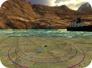
The right side displays a map of the south-ring; the left side shows different panels the user can modify in order to get different informations.
We are currently developing a web page on which people can make travel-time predictions along the south-ring.
This online interface can be found in this link.
Raw data used to perform the experiment described in [1] can be found in this link.
Related publications
[1]. Ladino, A, Kibangou A Y, Fourati H & Canudas de Wit, C. A real time forecasting tool for dynamic travel time from clustered fusion of clustered time series. Submitted to Transportation Research Part C: Emerging Technologies.
[2]. Ladino, A., Kibangou, A. Y., Fourati, H., & Canudas de Wit, C. (2016). Travel time forecasting from clustered time series via optimal fusion strategy. In European Control Conference, (pp. 4731–4736). Aalborg Denmark.
[3]. Canudas de Wit, C., Morbidi, F., Ojeda, L. L., Kibangou, A. Y., Bellicot, I., & Bellemain, P. (2015). Grenoble Traffic Lab: An Experimental Platform for Advanced Traffic Monitoring and Forecasting. in IEEE Control System Magazine - [Applications of Control]. (pp. 23-39) Volume 35- Issue 3.
Prediction module
Map
The whole south-ring is represented: the blue pins show the on-ramps, the purple ones the off-ramps. When you select (click on) a pin, its name is displayed in the panel From / To on the left side. A path is given by a couple (on-ramp, off-ramp), e.g., select (click on) a blue pin as an origin and a red pin as a destination to trace a particular path. You can change at any moment.
Panels
There are 2 main panels in the left side. The first panel in the upper part displays the origin/destination names and the time information about the prediction. The second panel contains time series information of Dynamic Travel Time (DTT) computed from real data received in real time and the prediction algorithm described in [1]. Real-time data and data predictions are displayed by default for past days or once real data is available. Data is collected every 15 seconds by sensors located in the south-ring, however predictions are available each minute.
Prediction, real and dynamic travel-time
To execute a prediction go into the left panel and determine one origin and one destination by selecting in the dropdown menu or click on the bullets located in the right hand side of the map (blue for inputs - red for outputs). Then then a time of departure or time of arrival and select a particular time. Finally click on Go to obtain the data. When executing the prediction the algorithm will compute the dynamic travel time for the actual instant of time. Computations are based in measurements taken up to the actual time and the travel time is predicted in a future horizon of 45mins. Once data is collected, (past days) the dynamic travel time is computed based on the real measurements taken in the highway. The two curves can be distinguished as red (predictions), blue (real)
Departure time suggestion
Once the system performs the prediction in adition a recomendation system selects the best and worst options for the predicted travel time. The optimal departure time is displayed with a green color bar and the optimal departure time is shown in the left part of the bar. The longest time trip is displayed in red.
